A Standard for Exchangeable Magnetotelluric Metadata
- Author:
Working Group for Data Handling and Software - PASSCAL Magnetotelluric Program
- Date:
Version 0.0.16 – July 2020 [1]
Introduction
Researchers using magnetotelluric (MT) methods lack a standardized format for storing time series data and metadata. Commercially available MT instruments produce data in formats that range from proprietary binary to ASCII, whereas recent datasets from the U.S. MT community have utilized institutional formats or heavily adapted formats like miniSEED. In many cases, the available metadata for MT time series are incomplete and loosely standardized; and overall, these datasets are not “user friendly”. This lack of a standardized resource impedes the exchange and broader use of these data beyond a small community of specialists.
The IRIS PASSCAL MT facility maintains a pool of MT instruments that are freely available to U.S. Principal Investigators (PIs). Datasets collected with these instruments are subject to data sharing requirements, and an IRIS working group advises the development of sustainable data formats and workflows for this facility. Following in the spirit of the standard created for MT transfer function datasets, this document outlines a new metadata standard for level 0,1,and 2 MT time series data (Data Levels). Following community approval of these standards, MTH5 (an HDF5 MT specific format) will be developed later in 2020.
The Python 3 module written for these standards and MTH5 is being developed at https://github.com/kujaku11/MTarchive/tree/tables.
General Structure
The metadata for a full MT dataset are structured to cover details from
single channel time series to a full survey. For simplicity, each of the
different scales of an MT survey and measurements have been categorized
starting from largest to smallest (Figure 1). These
categories are: Survey, Station, Run, DataLogger,
Electric Channel, Magnetic Channel, and Auxiliary Channel.
Each category is described in subsequent sections. Required keywords are
labeled as and suggested keywords are labeled as . A user should use as
much of the suggested metadata as possible for a full description of the
data.
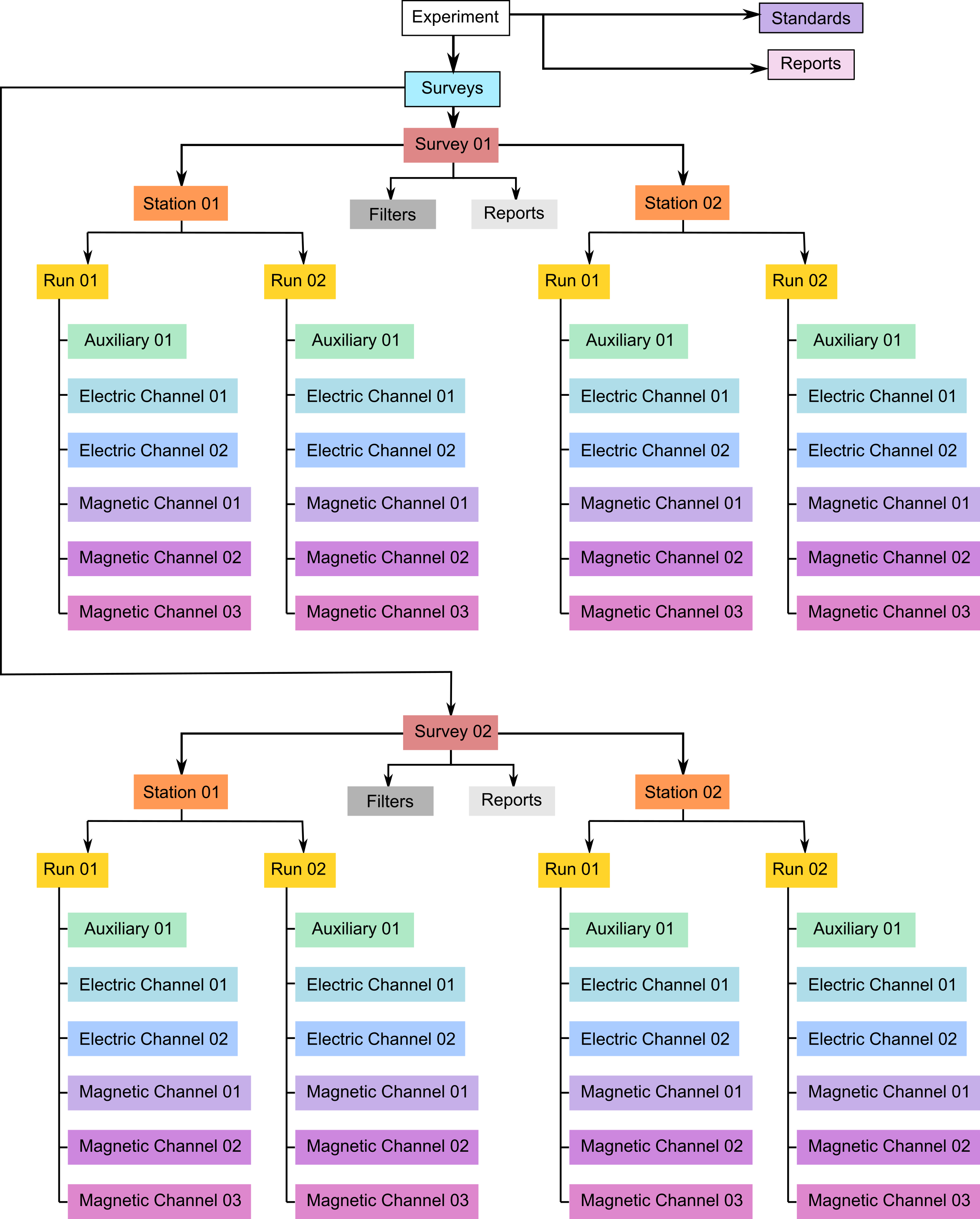
Schematic of a MT time series file structure with appropriate metadata. The top level is the Survey that contains general information about who, what, when, where, and how the data were collected. Underneath Survey are the Station and Filter. Filter contains information about different filters that need to be applied to the raw data to get appropriate units and calibrated measurements. Underneath Station are Run, which contain data that were collected at a single sampling rate with common start and end time at a single station. Finally, Channel describes each channel of data collected and can be an Auxiliary, Electric, or Magnetic. Metadata is attributed based on the type of data collected in the channel.
Metadata Keyword Format
The metadata key names should be self-explanatory and are structured as follows:
{category}.{name}, or can be nested
{category1}.{categroy2}.{name}where:
categoryrefers to a metadata category or level that has common parameters, such aslocation, which will have a latitude, longitude, and elevation
location.latitude,location.longitude, andlocation.elevation. These can be nested, for example,station.location.latitude
nameis a descriptive name, where words should be separated by an underscore. Note that only whole words should be used and abbreviations should be avoided, e.g.data_quality.
A ‘.’ represents the separator between different categories. The metadata can be stored in many different forms. Common forms are XML or JSON formats. See examples below for various ways to represent the metadata.
Formatting Standards
Specific and required formatting standards for location, time and date, and angles are defined below and should be adhered to.
Time and Date Format
All time and dates are given as an ISO formatted date-time String in the
UTC time zone. The ISO Date Time format is
YYYY-MM-DDThh:mm:ss.ms+00:00, where the UTC time zone is represented
by +00:00. UTC can also be denoted by Z at the end of the
date-time string YYYY-MM-DDThh:mm:ss.msZ. Note that Z can also
represent Greenwich Mean Time (GMT) but is an acceptable representation
of UTC time. If the data requires a different time zone, this can be
accommodated but it is recommended that UTC be used whenever possible to
avoid confusion of local time and local daylight savings. Milliseconds
can be accurate to 9 decimal places. ISO dates are formatted
YYYY-MM-DD. Hours are given as a 24 hour number or military time,
e.g. 4:00 PM is 16:00.
Location
All latitude and longitude locations are given in decimal degrees in the
well known datum specified at the Survey level. NOTE: The entire
survey should use only one datum that is specified at the Survey
level.
All latitude values must be
 and all longitude values
must be
and all longitude values
must be  .
.Elevation and other distance values are given in meters.
Datum should be one of the well known datums, WGS84 is preferred, but others are acceptable.
Angles
All angles of orientation are given in decimal degrees. Orientation of
channels should be given in a geographic or a geomagnetic reference
frame where the right-hand coordinates are assumed to be North = 0, East
= 90, and vertical is positive downward (Figure 2).
The coordinate reference frame is given at the station level
station.orientation.reference_frame. Two angles to describe the
orientation of a sensor is given by channel.measurement_azimuth and
channel.measurement_tilt. In a geographic or geomagnetic reference
frame, the azimuth refers to the horizontal angle relative to north
positive clockwise, and the tilt refers to the vertical angle with
respect to the horizontal plane. In this reference frame, a tilt angle
of 90 points downward, 0 is parallel with the surface, and -90 points
upwards.
Archived data should remain in measurement coordinates. Any
transformation of coordinates for derived products can store the
transformation angles at the channel level in
channel.transformed_azimuth and channel.transformed_tilt, the
transformed reference frame can then be recorded in
station.orientation.transformed_reference_frame.
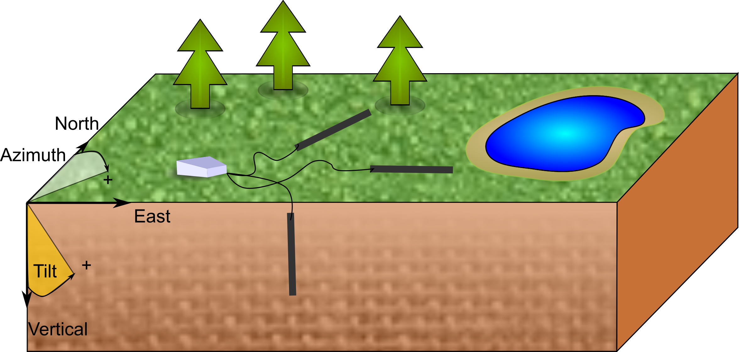
Diagram showing a right-handed geographic coordinate system. The azimuth is measured positive clockwise along the horizontal axis and tilt is measured from the vertical axis with positive down = 0, positive up = 180, and horizontal = 90.
Units
Acceptable units are only those from the International System of Units (SI). Only long names in all lower case are acceptable. Table 1 summarizes common acceptable units.
Measurement Type |
Unit Name |
|---|---|
Angles |
decimal degrees |
Distance |
meter |
Electric Field |
millivolt |
Latitude/Longitude |
decimal degrees |
Magnetic Field |
nanotesla |
Resistance |
ohms |
Resistivity |
ohm-meter |
Temperature |
celsius |
Time |
second |
Voltage |
volt |
String Formats
Each metadata keyword can have a specific string style, such as date and time or alpha-numeric. These are described in Table 2. Note that any list should be comma separated.
Style |
Description |
Example |
|---|---|---|
Free Form |
An unregulated string that can contain {a-z, A-Z, 0-9} and special characters |
This is Free Form! |
Alpha Numeric |
A string that contains no spaces and only characters {a-z, A-Z, 0-9, -, /, _} |
WGS84 or GEOMAG-USGS |
Controlled Vocabulary |
Only certain names
or words are
allowed. In this
case, examples of
acceptable values
are provided in the
documentation as [
option01 |
reference_frame = geographic |
List |
List of entries using a comma separator |
Ex, Ey, Bx, By, Bz, T |
Number |
A number according to the data type; number of decimal places has not been implemented yet |
10.0 (float) or 10 (integer) |
Date |
ISO formatted date YYYY-MM-DD in UTC |
2020-02-02 |
Date Time |
ISO formatted date time YYYY-MM- DDThh:mm:ss.ms+00:00 in UTC |
2020-02-02T1 2:20:45.123456+00:00 |
A valid email address |
||
URL |
A full URL that a user can view in a web browser |
https:// www.passcal.nmt.edu/ |
 option02
 Option Definitions
Electromagnetic Frequency Bands
Data Type |
Definition |
Frequency Range |
|---|---|---|
AMT |
radio magnetotellurics |
|
BBMT |
broadband magnetotellurics |
|
LPMT |
long-period magnetotellurics |
|

 –
– 

Channel Components
Channel Type |
Definition |
|---|---|
E |
electric field measurement |
B |
magnetic field measurement |
T |
temperature |
Battery |
battery |
SOH |
state-of-health |
Directions
Direction |
Definition |
|---|---|
x |
north direction |
y |
east direction |
z |
vertical direction |
# {0–9} |
variable directions |